- Basics/Related Info
- GOES-R 101
- GOES-R: Benefits of Next-Generation Environmental Monitoring
- GOES-R Fact Sheets
- Training By Subject
- Aerosols/Air Quality/Atmospheric Composition
- Aviation
- Climate
- Clouds
- Convection
- Fire
- General Satellite Meteorology
- Hydrology
- Imagery
- Instruments
- Lightning
- Space Weather
- Winds
- By Institute


Lightning Training Resources
Click on the thumbnail images or links below to launch/redirect to each training course.
Cooperative Program for Operational Meteorology, Education, and Training (Comet)
![]() The Cooperative Program for Operational Meteorology, Education, and Training supports, enhances, and stimulates the communication and application of scientific knowledge of the atmospheric and related sciences for the operational and educational communities. COMET’s web-based self-paced training materials serve earth science education and training needs by providing interactive experiences for learners at a distance. Experts at both the Cooperative Institute for Meteorological Satellite Studies (CIMSS) and the Cooperative Institute for Research in the Atmosphere (CIRA) contributed to many of these lessons.
The Cooperative Program for Operational Meteorology, Education, and Training supports, enhances, and stimulates the communication and application of scientific knowledge of the atmospheric and related sciences for the operational and educational communities. COMET’s web-based self-paced training materials serve earth science education and training needs by providing interactive experiences for learners at a distance. Experts at both the Cooperative Institute for Meteorological Satellite Studies (CIMSS) and the Cooperative Institute for Research in the Atmosphere (CIRA) contributed to many of these lessons.
GOES-R GLM: Introduction to the Geostationary Lightning Mapper
GOES-R GLM: Introduction to the Geostationary Lightning Mapper: This extension of the COMET module "GOES-R: Benefits of Next Generation Environmental Monitoring" focuses on the Geostationary Lightning Mapper (GLM) instrument. GLM provides continuous lightning measurements over a large portion of the Western Hemisphere, mapping total lightning (intra-cloud and cloud–to–ground) flash rates and trends. This module is also available in Spanish.
GOES-R Series Faculty Virtual Course: Geostationary Lightning Mapper
GOES-R Series Faculty Virtual Course: Geostationary Lightning Mapper: This course is part of a webinar series to provide university faculty and others with a solid basis for using GOES-R/16 data in coursework and student research projects. This module highlights the capabilities of the GOES-R/16 Geostationary Lightning Mapper (GLM) in both operational and research applications and how the GLM differs from land-based lightning detection.
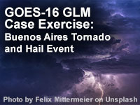
GOES-16 GLM Case Exercise: Buenos Aires Tornado and Hail Event
GOES-16 GLM Case Exercise: Buenos Aires Tornado and Hail Event: The GLM's continuous lightning monitoring capability is a valuable asset to detecting and monitoring developing thunderstorms 24 hours a day. This 30 minute lesson introduces learners to the benefits of using Geostationary Lightning Mapper (GLM) observations in assessing convection. Learners will explore a severe weather event near Buenos Aires, Argentina, and practice using GLM observations to determine initial convection, supplement other data tools in estimating tendencies in storm strength, and evaluate the potential for severe weather.
NASA’s Short-term Prediction Research and Transition Center (SPoRT)
![]() NASA’s Short-term Prediction Research and Transition Center (SPoRT) provides training about specific products, discussing the strengths and weaknesses, with the goal of successfully transitioning products to operations. This training is built from surveys and direct communication with our partners. With this paradigm, the forecasters are an integral component of the transition process and not a passive recipient of data.
NASA’s Short-term Prediction Research and Transition Center (SPoRT) provides training about specific products, discussing the strengths and weaknesses, with the goal of successfully transitioning products to operations. This training is built from surveys and direct communication with our partners. With this paradigm, the forecasters are an integral component of the transition process and not a passive recipient of data.
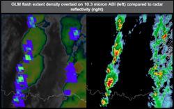
GLM Applications Overview
GLM Applications Overview: This micro-lesson for the Geostationary Lightning Mapper (GLM) provides an initial introduction to the utility of the flash extent density product that shows the number of flashes per grid box per minute. Three main applications are discussed that include physical reasoning behind GLM observations, using flash extent for decision support, and applying the product for lightning safety.
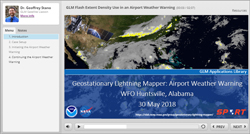
GLM Flash Extent Density use in an Airport Weather Warning
GLM Flash Extent Density use in an Airport Weather Warning: This micro-lession highlights the use f the Geostationary Lightning Mapper (GLM) Flash Extent Density product during an operational use to produce an airport weather warning.
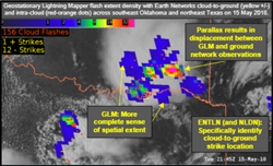
GLM and Ground Networks: Basics of Observations, Advantages, and Parallax
GLM and Ground Networks: Basics of Observations, Advantages, and Parallax: This micro-lesson discusses the Geostationary Lightning Mapper (GLM) with the available ground networks to detect lightning. GLM detects total lightning and is visualized quite differently from the ground networks. This will be illustrated through several examples. The lesson includes a basic inter-comparison of the GLM and the ground networks, strengths of each respective system, and parallax of the GLM.

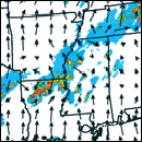
Lightning provides advanced lead time for tornado event
Lightning provides advanced lead time for tornado event: Total lightning trends provide a proxy to storm stage and a “jump” in activity can be a precursor to severe weather. This case demonstrates the application of total lightning source density (similar to ‘events’ from GLM) along with radar data to anticipate severe weather, which resulted in a tornado event.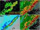
Lightning Operational Uses: Severe Weather
Lightning Operational Uses: Severe Weather: This is a follow-up to the Total Lightning Training: Part 1 module and assumes a basic knowledge of total lightning. This sub-section focuses on the most common use of total lightning; severe weather decision support. This module focuses on the use of lightning jumps for three different events. These include a severe wind and hail event as well as a tornadic event. The full module includes the safety and additional scenarios sub-sections.
Lightning Training: Part 1
Lightning Training: Part 1: This module introduces the user to total lightning and the source density product provided by NASA SPoRT.
WRF Model Lightning Forecast Algorithm (LFA)
WRF Model Lightning Forecast Algorithm (LFA): This tutorial provides background information on the development, calibration, and application of the lightning forecast algorithm (LFA), as implemented into the Weather Research and Forecasting (WRF) numerical weather prediction model. The LFA is a demonstration product for use in the GOES-R Proving Ground to develop model proxy fields of total lightning that could be used in future data assimilation applications of the Geostationary Lightning Mapper.
Virtual Institute for Satellite Integration Training (VISIT)
 Virtual Institute for Satellite Integration Training (VISIT) is a joint effort involving NOAA Cooperative Institutes, the National Environmental Satellite Data and Information Service (NESDIS), and the National Weather Service (NWS). The primary mission of VISIT is to accelerate the transfer of research results based on atmospheric remote sensing data into NWS operations using distance education techniques. Training sessions include topics on satellite meteorology, severe weather, climate, numerical weather prediction, and more.
Many of these modules were developed in collaboration with the Cooperative Institute for Meteorological Satellite Studies (CIMSS) and the Cooperative Institute for Research in the Atmosphere (CIRA). VISIT also provides satellite chats to demonstrate satellite products that can be applied to operational forecasting and identify new training topics based on specific participant needs. See the VISIT Training Calendar for upcoming teletraining sessions.
Virtual Institute for Satellite Integration Training (VISIT) is a joint effort involving NOAA Cooperative Institutes, the National Environmental Satellite Data and Information Service (NESDIS), and the National Weather Service (NWS). The primary mission of VISIT is to accelerate the transfer of research results based on atmospheric remote sensing data into NWS operations using distance education techniques. Training sessions include topics on satellite meteorology, severe weather, climate, numerical weather prediction, and more.
Many of these modules were developed in collaboration with the Cooperative Institute for Meteorological Satellite Studies (CIMSS) and the Cooperative Institute for Research in the Atmosphere (CIRA). VISIT also provides satellite chats to demonstrate satellite products that can be applied to operational forecasting and identify new training topics based on specific participant needs. See the VISIT Training Calendar for upcoming teletraining sessions.
VISIT Training Sessions:
VISIT offers a wide selection of satellite remote sensing training materials. See the VISIT Training Sessions webpage for a complete listing.
FDTD Satellite Application Webinars:
The National Weather Service Forecast Decision Training Division (FDTD) Satellite Application Webinars are peer-to-peer learning; staff from Weather Forecast Offices (WFOs), National Centers, Center Weather Service Units (CWSUs), and River Forecast Centers (RFCs) lead the presentations. The webinars to share how to apply GOES imagery with other datasets for a specific operational application.