- Basics/Related Info
- GOES-R 101
- GOES-R: Benefits of Next-Generation Environmental Monitoring
- GOES-R Fact Sheets
- Training By Subject
- Aerosols/Air Quality/Atmospheric Composition
- Aviation
- Climate
- Clouds
- Convection
- Fire
- General Satellite Meteorology
- Hydrology
- Imagery
- Instruments
- Lightning
- Space Weather
- Winds
- By Institute


Training: Imagery
Click on the thumbnail images or links below to launch/redirect to each training course.
Cooperative Program for Operational Meteorology, Education, and Training (Comet)
![]() The Cooperative Program for Operational Meteorology, Education, and Training supports, enhances, and stimulates the communication and application of scientific knowledge of the atmospheric and related sciences for the operational and educational communities. COMET’s web-based self-paced training materials serve earth science education and training needs by providing interactive experiences for learners at a distance. Experts at both the Cooperative Institute for Meteorological Satellite Studies (CIMSS) and the Cooperative Institute for Research in the Atmosphere (CIRA) contributed to many of these lessons.
The Cooperative Program for Operational Meteorology, Education, and Training supports, enhances, and stimulates the communication and application of scientific knowledge of the atmospheric and related sciences for the operational and educational communities. COMET’s web-based self-paced training materials serve earth science education and training needs by providing interactive experiences for learners at a distance. Experts at both the Cooperative Institute for Meteorological Satellite Studies (CIMSS) and the Cooperative Institute for Research in the Atmosphere (CIRA) contributed to many of these lessons.
GOES-R Series Faculty Virtual Course: Multispectral RGB Composites
GOES-R Series Faculty Virtual Course: Multispectral RGB Composites: This course is part of a webinar series to provide university faculty and others with a solid basis for using GOES-R/16 data in coursework and student research projects. This module discusses the capabilities of the GOES-R/16 red-green-blue (RGB) composites. Multispectral or RGB composites are qualitative, false color images designed to enhance specific features in the atmosphere that are important to forecasters, aviators, mariners, and emergency response officials.
GOES-R Series Faculty Virtual Course: RapidScan Imaging
GOES-R Series Faculty Virtual Course: RapidScan Imaging: This course is part of a webinar series to provide university faculty and others with a solid basis for using GOES-R/16 data in coursework and student research projects. This module presents GOES-16/GOES-R 30-second and 1-minute rapid scan imagery to demonstrate unprecedented views of convection, wildfire, storm intensification, and other quickly-evolving features.
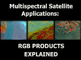
RGB Products Explained
RGB Products Explained: This module provides an overview of meteorological and environmental RGB products, namely, how they are constructed and how to use them. This module is also available in Spanish.
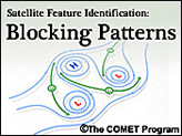
Satellite Feature Identification: Blocking Patterns
Satellite Feature Identification: Blocking Patterns: Examines how water vapor imagery can be used to help diagnose blocking patterns and their dissipation. Four major blocking patterns are covered in this module: blocking highs, cut-off lows, Rex blocks, and Omega blocks. This module is also available in French and Spanish.
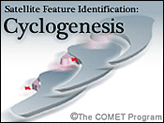
Satellite Feature Identification: Cyclogenesis
Satellite Feature Identification: Cyclogenesis: This module uses water vapor satellite imagery to present a satellite perspective of basic features associated with the formation and development of extratropical cyclones.
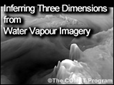
Satellite Feature Identification: Inferring Three Dimensions from Water Vapour Imagery
Satellite Feature Identification: Inferring Three Dimensions from Water Vapour Imagery: Water vapor imagery can help us break out of flatland and move to more dimensions. This imagery holds so much under-utilized potential. We can actually see three-dimensional structures evolving in near-real-time. This module is also available in French.
NASA’s Short-term Prediction Research and Transition Center (SPoRT)
![]() NASA’s Short-term Prediction Research and Transition Center (SPoRT) provides training about specific products, discussing the strengths and weaknesses, with the goal of successfully transitioning products to operations. This training is built from surveys and direct communication with our partners. With this paradigm, the forecasters are an integral component of the transition process and not a passive recipient of data.
NASA’s Short-term Prediction Research and Transition Center (SPoRT) provides training about specific products, discussing the strengths and weaknesses, with the goal of successfully transitioning products to operations. This training is built from surveys and direct communication with our partners. With this paradigm, the forecasters are an integral component of the transition process and not a passive recipient of data.
Air Mass RGB
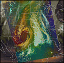
Air Mass RGB: This micro-lesson is focused on an application of the Air Mass RGB to anticipate rapid cyclogenesis and high impact winds. The case presented is the development of a storm force low in the Western Atlantic and the use of the RGB to anticipate changes in cyclone intensity and associated impacts such as high wind. Basic interpretation and description of the R-G-B components are presented. Download Air Mass RGB Quick Guide (PDF).
Day Land Cloud Fire RGB
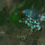
Day Land Cloud Fire RGB: The focus of this micro-lesson is on the Natural Color Fire RGB product. This RGB is similar to the Day Land Cloud or Natural Color RGB; however, one of the channels is replaced to specifically focus on fire hot spots. The RGB allows one to view the smoke and fire hot spots within the same product. The case used for this object is the October 2017 Northern California Firestorm. The objective for this item is to have the forecaster demonstrate the ability to identify various hot spots within the Day Land Cloud Fire RGB imagery.
Dust RGB
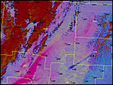
Dust RGB: This micro-lesson demonstrates the value of applying Dust RGB imagery from the GOES-R ABI via an event from March 2017 in the U.S. Southwest. The Dust RGB is compared to traditional visible and infrared single-channel imagery to show the operational value of the multi-channel RGB imagery for analyzing blowing dust plumes during both day and night. Download Dust RGB Quick Guide (PDF).
Dust RGB identifies aviation ceiling hazard at KFMN
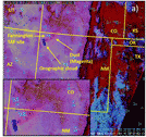
Dust RGB identifies aviation ceiling hazard at KFMN: This seven-minute micro-lesson of the dust RGB application to a mesoscale event that impacted the ceiling conditions at the Farmington, New Mexico, airport (i.e. TAF site). Observations at the site and the changes to the TAF are highlighted. The lesson also illustrates the value of the dust RGB with the GOES visible and MODIS/VIIRS true color imagery.
Nighttime Microphysics RGB
Nighttime Microphysics RGB: This micro-lesson demonstrates the operational use of the Nighttime Microphysics RGB both to increase the lead time or to avoid a ‘false alarm’ of advisory products related to fog hazards. The RGB is compared to the traditional split window difference of the long and short-wave infrared channels for the identification of low clouds and fog. Other mid- and upper-level clouds are apparent in the RGB, but they are not the focus of this particular training. Download Nighttime Microphysics RGB Quick Guide (PDF)
Virtual Institute for Satellite Integration Training (VISIT)
 Virtual Institute for Satellite Integration Training (VISIT) is a joint effort involving NOAA Cooperative Institutes, the National Environmental Satellite Data and Information Service (NESDIS), and the National Weather Service (NWS). The primary mission of VISIT is to accelerate the transfer of research results based on atmospheric remote sensing data into NWS operations using distance education techniques. Training sessions include topics on satellite meteorology, severe weather, climate, numerical weather prediction, and more.
Many of these modules were developed in collaboration with the Cooperative Institute for Meteorological Satellite Studies (CIMSS) and the Cooperative Institute for Research in the Atmosphere (CIRA). VISIT also provides satellite chats to demonstrate satellite products that can be applied to operational forecasting and identify new training topics based on specific participant needs. See the VISIT Training Calendar for upcoming teletraining sessions.
Virtual Institute for Satellite Integration Training (VISIT) is a joint effort involving NOAA Cooperative Institutes, the National Environmental Satellite Data and Information Service (NESDIS), and the National Weather Service (NWS). The primary mission of VISIT is to accelerate the transfer of research results based on atmospheric remote sensing data into NWS operations using distance education techniques. Training sessions include topics on satellite meteorology, severe weather, climate, numerical weather prediction, and more.
Many of these modules were developed in collaboration with the Cooperative Institute for Meteorological Satellite Studies (CIMSS) and the Cooperative Institute for Research in the Atmosphere (CIRA). VISIT also provides satellite chats to demonstrate satellite products that can be applied to operational forecasting and identify new training topics based on specific participant needs. See the VISIT Training Calendar for upcoming teletraining sessions.
VISIT Training Sessions:
VISIT offers a wide selection of satellite remote sensing training materials. See the VISIT Training Sessions webpage for a complete listing.
FDTD Satellite Application Webinars:
The National Weather Service Forecast Decision Training Division (FDTD) Satellite Application Webinars are peer-to-peer learning; staff from Weather Forecast Offices (WFOs), National Centers, Center Weather Service Units (CWSUs), and River Forecast Centers (RFCs) lead the presentations. The webinars to share how to apply GOES imagery with other datasets for a specific operational application.