First Lightning Imagery from GOES-17
May 21, 2018
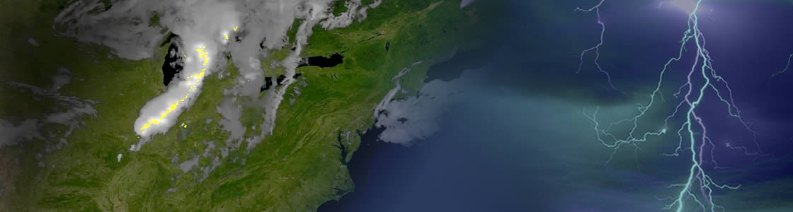
NOAA’s GOES-17 satellite has transmitted its first Geostationary Lightning Mapper (GLM) data. The new GLM observed a round of severe storms forming during peak daytime heating on May 9, 2018, over Wisconsin and Illinois. These storms quickly grew into an impressive line of storms that persisted into the evening and overnight hours, producing large hail, high winds, and a few tornadoes.
The Geostationary Lightning Mapper (GLM) like the one on board NOAA GOES East, is transmitting data never previously available to forecasters. GLM detects the light emitted by lightning at the tops of clouds both day and night and collections information such as the frequency, location and extent of lightning discharges. The instrument continuously measures total lightning, both in-cloud and cloud-to-ground, to aid in forecasting developing severe storms and a wide range of high-impact environmental phenomena. Trends in total lightning available from GLM provide critical information to forecasters, allowing them to focus on initial thunderstorm development and intensifying severe storms before these storms produce damaging winds, hail or even tornadoes. Such storms often exhibit a significant increase in total lightning activity, particularly in-cloud lightning.
During heavy rain, GLM data can show when thunderstorms are stalled or if they are gathering strength. When combined with radar and other satellite data, GLM data will help forecasters anticipate severe weather and issue flood and flash flood warnings sooner.
Also, in large long-lived storm systems, lightning may travel hundreds of miles before striking the ground. GLM can show forecasters areas far from the main line of storms where the risk of lightning strikes to ground presents a public safety hazard. In dry areas, especially in the western United States, information from the instrument will help forecasters, and ultimately firefighters, identify areas prone to wildfires sparked by lightning.
This will be an essential component to keeping American lives and property safe when GOES-17 is positioned in its operational GOES West position where it will cover a vast swath of the data-sparse Pacific Ocean and monitor high-risk wildfire-prone areas in the Western U.S.